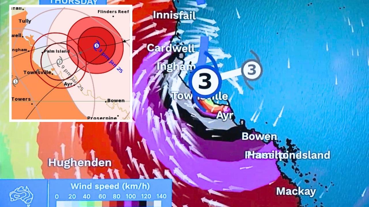
Schools, airports and businesses have been shuttered in Townsville as the city is ordered into lockdown ahead of wild storms caused by Cyclone Kirrily.
Kirrily was upgraded to a category 3 cyclone on Thursday afternoon as it accelerates towards the north Queensland coast, expected to make landfall late on Thursday evening.
The system is fast approaching the coastal city of Townsville, with nearly 200,000 residents told to brace for 170km/h winds that will sweep a 160-kilometre stretch from Ingham to Ayr.
Residents in croc country were urged to take extra precautions as the rainfall from Kirrily is expected to cause flooding, which could sweep up crocodiles and give them paths into residential areas.
Disaster Recovery Minister Nikki Boyd said there were “two events” Queenslanders needed to prepare for — gale force winds and flooding.
“My message is if it’s flooded, forget it. It is not safe to cross flood waters, particularly not in croc country,” she said.
Ms Boyd also urged residents to decide on Thursday whether they will stay in their homes to wait out the cyclone or seek refuge.
“We have those evacuation centres that are set up now, and ready to take people across the area,” she said.
Heavy rainfall was already recorded on Thursday, with 100mm falling on Clarke Range, inland of Mackay, in just a few hours.
Strong winds were also clocked, particularly over Queensland’s offshore reefs, including 142km/h at Flinders Reef and 114km/h at Whitsundays.
“It’s these very strong sustained winds that we expect to see pushing onto those coastal mainland areas over the next few hours,” Bureau of Meteorology meteorologist Miriam Bradbury said.
Conditions are expected to deteriorate rapidly after sunset.
The BOM’s tropical cyclone warning zone extends from Innisfail to Sarina, including Townsville and Mackay, and pushes inland as far as Hughenden.
“We’ll see those sustained gale force winds and heavy rainfall really picking up through our warning area. The combination of the winds and the rain do have the potential to bring down trees and powerlines leading to road closures and possible power failures,” Ms Bradbury warned.
Hundreds of millimetres of rainfall are expected to fall over large parts of the warning zone in just a few hours, which could quickly lead to flash flooding.
Dangerous storm surges are also expected, though they are unlikely to occur at high tide.
“That’s good news, but we are still expecting to see some abnormally high tides around the time of the [cyclone’s] crossing,” Ms Bradbury said.
“In addition to that storm tide we’re likely to see large waves and dangerous swells.”
Kirrily is expected to “rapidly decay” as it travels inland, becoming a category one system by early Friday morning and dropping back to a tropical low by Friday afternoon.
But that doesn’t mean the threat is over.
A severe weather warning is in place for large parts of inland north Queensland, which are expected to shoulder intense rainfall and strong winds for days after Kirrily’s crossing.
“The wind gusts will back down as that system moves inland but strong and gusty winds possibly damaging are still expected,” Ms Bradbury explained.
“Once the system is no longer a tropical cyclone, it won’t get the tropical cyclone warning, we’ll have a severe weather warning covering the impacts from that system [instead]. They’re both warning for the same dangers.”
