Good rains (287mm) in Aug, however, could not bring down the overall temperature during the month as it reported the highest average minimum temperature and fourth-highest average mean temperature since 1901.
This can be attributed to variation in spatial distribution of rainfall – northwest India got 32% more than ‘normal’ rainfall in Aug (second highest in the month since 2001), whereas south peninsula received merely around 1% more than normal rains in the month.
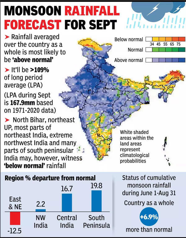
Though the country as a whole is likely to get ‘above-normal’ rainfall in Sept, in certain areas – north Bihar, northeast UP, most parts of northeast India, extreme northwest India and many parts of south peninsular India – it is likely to be ‘below normal’. Overall, the four-month (June-Sept) monsoon season, as predicted in mid-April, will be logged as ‘above-normal’ rainfall activity.
Good rains in Aug, mainly in ‘monsoon core’ zone (rainfed areas), already had its positive impact on kharif sowing. Total acreage of the season is well on course to cross ‘normal’ (average of past five years) sown area, indicating possibility of a higher foodgrain output in the crop year. Good rains in monsoon season also mean adequate soil moisture and enough water in reservoirs to feed rabi (winter-sown) crops.
La Nina phenomenon has, however, not yet formed. It is now expected to be formed by Sept-end, but it won’t have any effect on the current rainy season as the summer monsoon may, by that time, be in its withdrawal phase.
La Nina during Sept-Nov generally weakens the northeast (winter) monsoon in southeast India.
“It is, however, too early to predict its impact. We would be able to say anything on this by Sept-end. We’ll also see how the La Nina will lead to cyclonic conditions,” said Mrutyunjay Mohapatra, director general, IMD.
On the reasons for heavy rainfall in Aug, he said six low-pressure systems formed during the month (out of that one became a deep depression and another a cyclone) could be one of the major influencing factors. Aug generally sees an increase in trend for the ‘break’ (pause) days of monsoon, but such a phase was missing this time and the month could see one of the highest number of active days in the recent past. Earlier such high numbers of active days were observed in 2020 and 2022.
Mohapatra said, “Above-normal maximum (day) temperatures are likely over most parts of the country, except for some areas in northwest India, south peninsular India, and some pockets of east-central India, where normal to below-normal maximum temperatures are likely.”