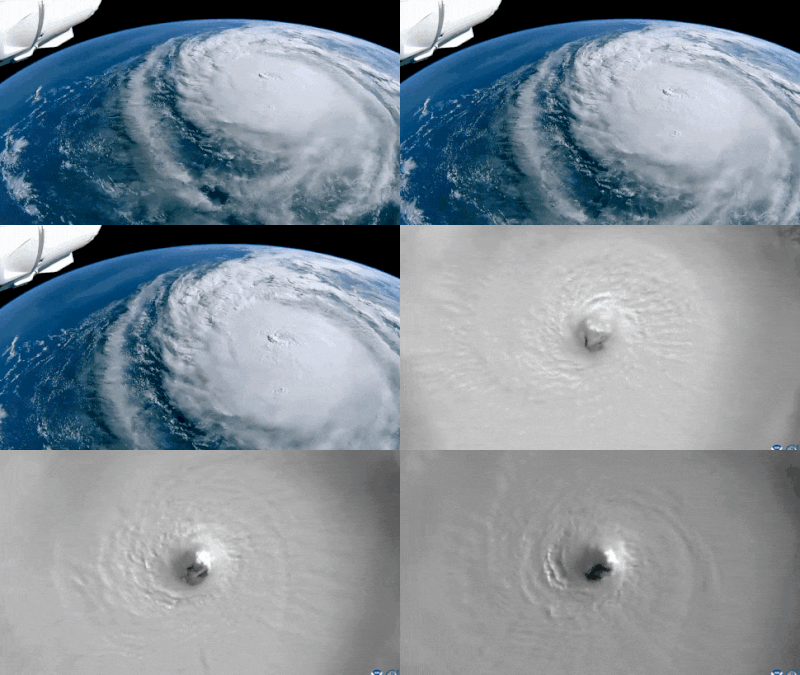
The International Space Station (ISS) captured birds-eye view of Hurricane Milton as it re-intensifies into a Category 5 storm while moving across the southern Gulf of Mexico towards Florida.
At 10:28 am EDT on October 7, the ISS flew over the hurricane, capturing the powerful storm with its external cameras.
The space station shared the footage on X said, “At 10:28 am EDT October 7, the space station flew over Hurricane Milton and external cameras captured views of the category 5 storm, packing winds of 175 miles an hour, moving across the Gulf of Mexico toward the west coast of Florida.”
Nasa astronaut Matthew Dominick filmed a timelapse video from the Dragon Endeavour spacecraft, showing the immense scale of the storm.
Meanwhile, National Oceanic and Atmospheric Administration (NOAA) researchers have been flying through the hurricane, gathering data to aid forecasters in making precise predictions regarding its trajectory and intensity.
Hurricane Milton transformed from a Category 1 to a Category 5 storm within hours on Monday, stunning forecasters. It currently ranks as the fifth most intense Atlantic storm on record. However, it has since weakened to a Category 4 system, with sustained winds of 180 mph.
The storm is expected to maintain its strength as it approaches Florida’s Tampa Bay region, where it is anticipated to make landfall either late Wednesday night (October 9) or early Thursday (October 10).
NOAA’s Geostationary Operational Environmental Satellite (GOES) has also provided images of Hurricane Milton’s movement above the Yucatan Peninsula. The imagery reveals the storm’s powerful convection currents, with black and red hues near the center indicating cold temperatures and deep thunderstorms. According to NOAA, these intense storms suggest significant vertical heat and moisture transportation within the atmosphere.
Additionally, footage from the GOES-19 satellite, shared by Colorado State University’s Cooperative Institute for Research in the Atmosphere (CIRA), highlights the hurricane’s “powerful, small eye.”
Another CIRA video reveals lightning flashes within Milton’s eye wall, underlining the storm’s severe nature.
Noah Bergren, a meteorologist at Fox 35 Orlando, expressed his astonishment on social media, writing, “This is nothing short of astronomical. I am at a loss for words to meteorologically describe [to] you the storms small eye and intensity. This hurricane is nearing the mathematical limit of what Earth’s atmosphere over this ocean water can produce.”
As Hurricane Milton barrels toward Florida, residents are bracing for potential impact while officials issue warnings and safety guidelines in anticipation of the storm’s landfall.
