Australia is on track for its driest September on record, as sky-high temperatures are clocked in several states.
Rainfall across Australia has been about 70 per cent below average overall, according to Bureau of Meteorology senior climatologist David Wilson.
The Murray-Darling Basin, a major source of Australia’s food and water supply, has been particularly dry, receiving rainfall that was about 85 per cent below its September average.
Unless there’s a mammoth deluge in the next few days — there’s not one in the forecast — it means this month will be Australia’s driest September since records began, Dr Wilson said.
While rainfall has been unusually low, temperatures have also been unusually high across most of the country, with record maximums set in several cities.
Sydney clocked its hottest-ever September day earlier this month when the mercury climbed past 34C. This week, temperatures in the Perth metro area hit 34.3C, beating the WA capital’s previous September record of 34.2C, which was set in 2014.
“New maximum and (high) minimum temperature records were set at many sites across southern Australia,” Dr Wilson said on Thursday.
“A number of locations, including central NSW, experienced a record number of consecutive days that were very much warmer than usual.”
Soil moisture has fallen below average “across large areas of southern Australia” and the ground is continuing to dry out, Dr Wilson said.
Together, Australia’s water storages are about 80 per cent full, but some storages have dropped below a worrying 50 per cent, he added.
Long range forecast: October to December
The BOM’s long range forecast indicates the hot, dry conditions will stick around until at least the end of the year.
Australia is likely to receive below average rainfall over the coming months, with an increased chance of an abnormally dry summer.
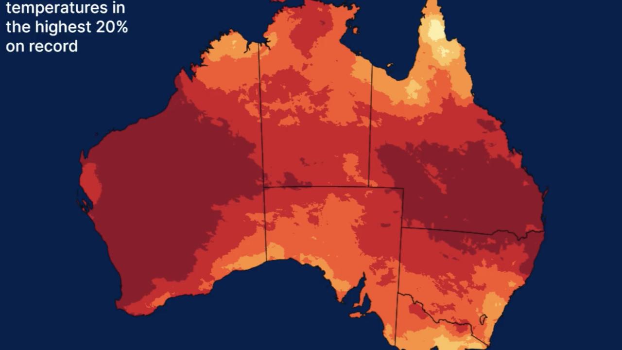
An extraordinary map provided by the BOM shows daytime temperatures from October to December are very likely to be warmer than average across almost all of Australia. Overnight temperatures, too, are likely to be warmer than usual in most areas.
Dr Wilson said the forecast reflected El Nino, which typically brings hot and dry conditions to Australia’s southeast.
The El Nino climate driver pulls warmer water away from eastern Australia. Cooler waters leads to less cloud cover which in turn leads to less rainfall.
“We know that with a warmer climate comes an increased risk of extremes such as heatwaves and bushfires,” he said.
Australia’s September long weekend weather
In the more immediate future, millions of Aussies can expect a balmy long weekend as the ACT, NSW and SA celebrate Labour Day, Queensland celebrates the King’s Birthday and Victoria celebrates the AFL Grand Final.
A pocket of heat is travelling eastwards from WA and is set to hit SA on Saturday and NSW on Sunday.
In Adelaide, temperatures could be 12 to 14 degrees above average, while the mercury in Sydney could peak at 35C in the CBD on Sunday. If that forecast is met, it will be the hottest ever day in the Harbour City this early in spring.
That could mean the NRL Grand Final kicks off in the evening with temperatures still north of 30C.
Sky News meteorologist Alison Osborne said it’s more likely to be a heat seesaw or a heat rollercoaster than it is to be heatwave.
The hot days are likely to be interspersed with cooler maximums, Ms Osborne told news.com.au.
“The long weekend is shaping up to be a hot one across southern and eastern Australia with some big day-to-day swings for our capitals,” she explained.
“A hot dry air mass is migrating from the west across southern regions during Friday”.