The “hottest September weather in six years” is set to sweep through Sydney, just days after Adelaide saw its warmest day in six months, as a “record challenging” bubble of heat squats over Australia’s south and east.
Parts of New South Wales, Victoria and South Australia could exceed 35C little more than two weeks out from winter.
Next week, Adelaide is looking at temperatures of up to 16 degrees above average.
It comes as parts of the Australian Alps saw their warmest September day on record.
“A high in the Tasman Sea is now in a ‘blocking’ pattern for the next five days essentially squishing any cold fronts, pushing them well south of the mainland,” Sky News Weather meteorologist Alison Osborne told news.com.au.
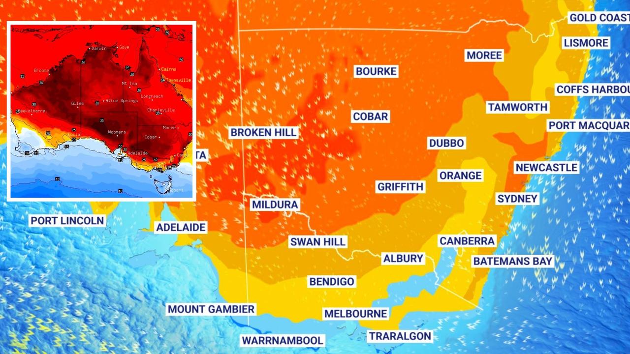
Winds circling the high pressure system are dragging warm air down from northern and Central Australia towards the south and east.
“Daytime temperatures are very high by September standards,” Ms Osborne added.
‘Hottest September weather in six years’
“From Thursday to Tuesday, temperature anomalies of 8-12 degrees above average are across the south and east peaking at 12-16 degrees above average in South Australia on Sunday and Monday.
“The heat in the Sydney on Monday and Tuesday could be in the mid-thirties which would be the city’s hottest September weather in six years”.
However, Ms Osborne said the weather couldn’t strictly be called a heatwave.
This is because according to the Bureau of Meteorology, a heatwave is defined as above average maximums and minimum temperatures for several concurrent days.
But as the mercury will dip overnight to comfortable levels that will keep heat stress at bay.
Up to 16 degrees above average
On Thursday, Adelaide saw temperatures rise to just shy of 29C in the CBD.
Friday will see a dip to 21C but then it starts to creep up with 24C on Saturday and 29C on Sunday. At this time of year, maximums in the mid-teens are more usual.
“Monday looks to be record challenging in the southern inland,” said Ms Osborne.
“The border regions between SA, Victoria and NSW could exceed 35C.”
If records break it will be in places like Renmark where it could hit 28C on Friday climbing to the mid-thirties on Sunday and Monday.
Mildura could reach 33C on Sunday and 36C on Monday; 32C in Cobram to start the week is a possibility with almost 30C in Wangaratta.
Heading towards the coast, however, and the high pressure system begins to lose its power. Temperatures will still peak but less dramatically.
Winds will ease in Melbourne on Thursday with a 23C high rising to 25C on a sunny Saturday. Temperatures should remain in the mid-twenties during a cloudy weekend and into next week.
It will be Wednesday before the maximum settles down to a more average spring like 17C.
The cold front will brush through Tasmania where conditions are far more standard.
A 19C high in Hobart on Friday will fall to 17C on a rainy Saturday and 16C on Sunday. Although, Tuesday could see temperatures reach 20C.
Heading back to the mainland and the ski regions have been uncommonly toasty with maximums 11 degrees above average.
Thursday’s 16C at Falls Creek was the highest September temperature since record keeping began there, but to note that was only in 1990.
Sydney could pass 36C
Canberra will have a sunny runny of days with a 24C high on Friday, 25C on Sunday and 27C on Monday and Tuesday in the capital.
A spring scorcher in Sydney on Saturday reaching 31C at Circular Quay, following 26C on Friday.
From Sunday until at least Wednesday the Harbour City will be a run of 30C or near 30C days.
Penrith, in the city’s west, likely won’t dip below a 30C maximum until Thursday. The hottest day is looking like Monday at 36C after a 33C weekend.
The clear skies will let the daytime heat escape quickly. Overnight in Sydney, it will fall to the mid-teens or not much more than 10C in Penrith.
Inland, Dubbo will peak at 33C on Monday; Griffith 35C on the same day and Tamworth 32C.
Coastal areas of the state are all likely to see 30C on the weekend or Monday, with the possible exception of the far north coast.
Brisbane could push into the thirties on Wednesday of next week and potentially see 33C on Thursday. But a touch milder for the coming days with 25C on Friday and 27C on Sunday.
Townsville is stuck on a rinse and repeat of days reaching 29C for the coming week.
Dry in Darwin with 33C highs and 21C lows.
A high of 22C in a showery Friday in Perth. Saturday may also see some rain and 22C with the moisture moving away for a dry Sunday at 20C. Similar maximums will settle in for the start of the week but sunshine could warm things up from Wednesday in the WA capital.